Q-Bam Historical Map Thread

dewb3qc-d147372b-4c23-44ec-8970-fa85b288847f.png

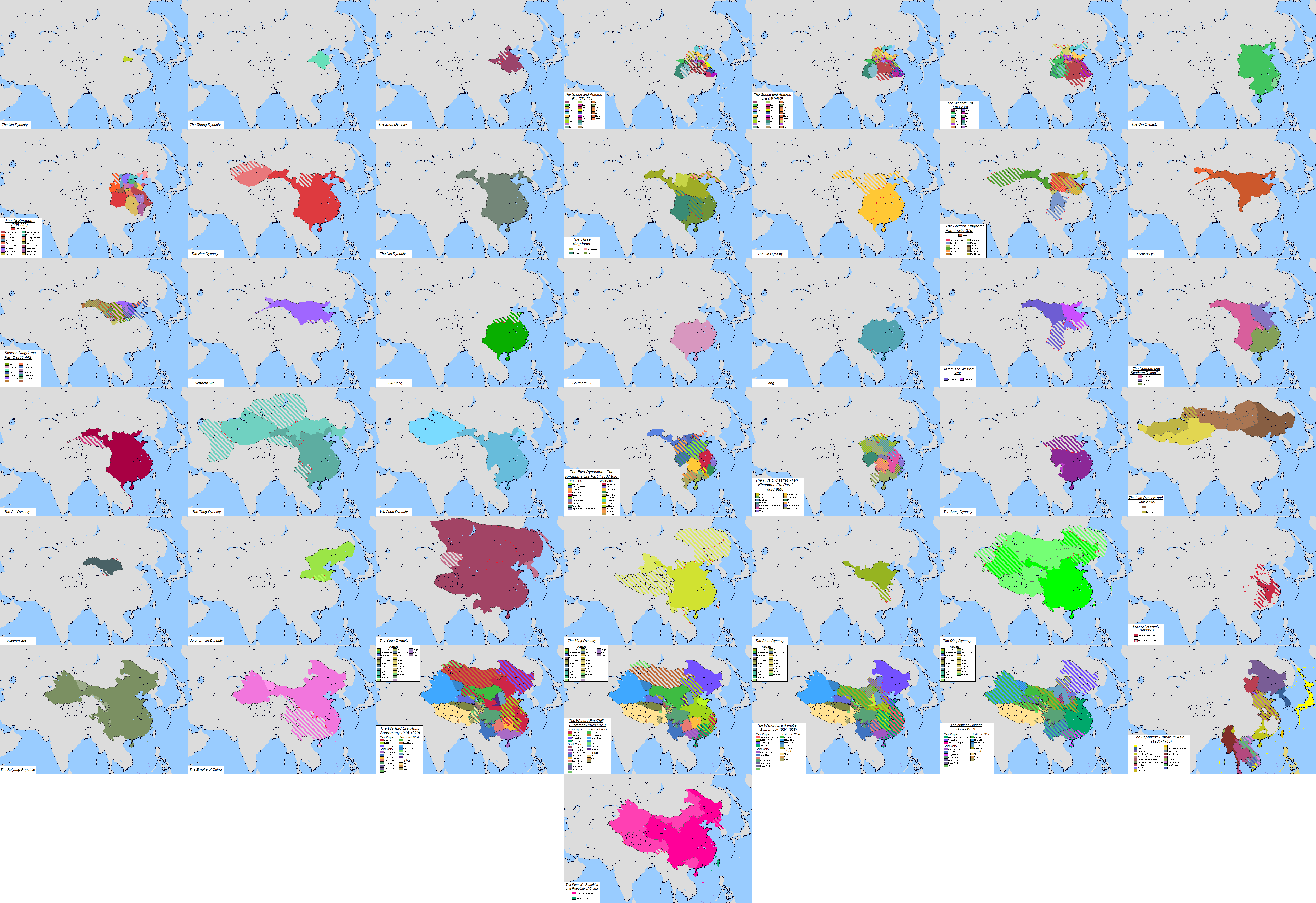
History of the many, many states of China. This took me forever to do, and it feels good to get it done
dev5m3p-7a823aa9-721e-4869-8ba6-ef1d17344a99.png

Here's the legend for it. Didn't add it to the map because it would ruin the symmetry
Edit: Fixed some coastlines on panels 39-42
 
Last edited:
devae5k-31a1dde8-279b-4c0e-94a8-93a0feac1bec.png

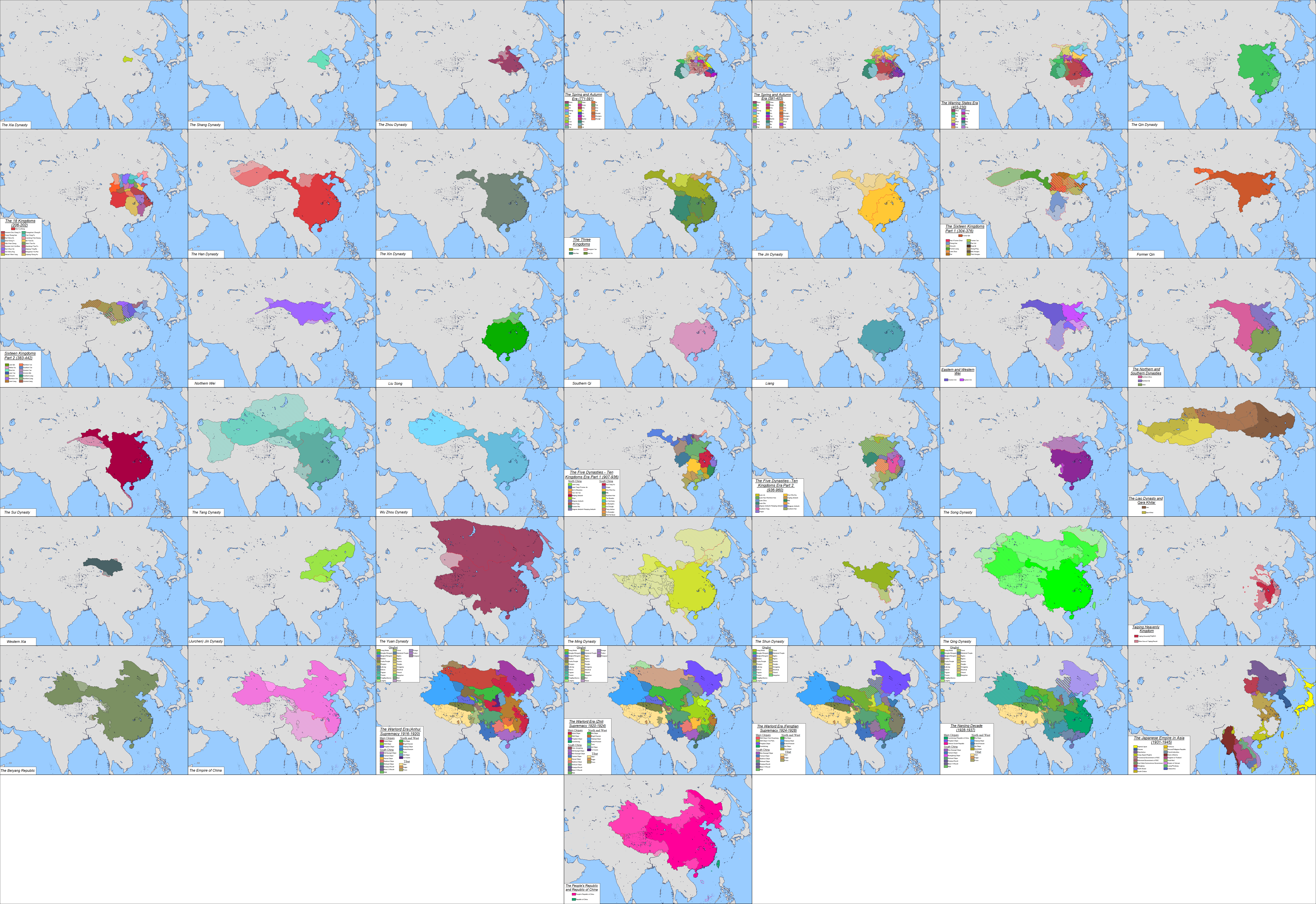
History of the many, many states of China. This took me forever to do, and it feels good to get it done
dev5m3p-7a823aa9-721e-4869-8ba6-ef1d17344a99.png

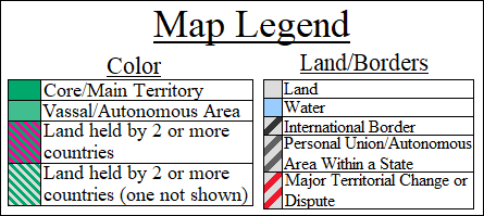
Here's the legend for it. Didn't add it to the map because it would ruin the symmetry
Edit: Fixed some coastlines on panels 39-42
Great work, found only one mistake: a part of territory between the salween river and thailand was in fact not annexed by the latter as far as im aware, only claimed.
 
WVoATMq.png

6PbccQm.png

so, i was compositing a map together, and i decided to compare the two versions of late medieval france we have to see which one is more accurate, since i needed it for my map, and the shape of the northeastern border on the first one looked sus to me (compared to what ive seen on wikipedia or in a paradox game) i think it should cut into modern france? oh yeah, ive overlaid modern france on each one since modern q-bam is the base/standard all the maps are based off of so that one must be right. the thing is, im not entirely sure what modern france pasted over medieval france should look like, i do have a copy of euratlas on here but just making this post took literal hours and like 10 crashes because my pc is busted.

yh i think the bishopric of cambray would be in modern france instead of modern belgium for example. no shade is meant by this post, they are both very useful resources and must of taken ages to make. some bits could do with being stretched over i guess.

this is my second time writting out this blurb, so appologies if its incoherent.
What program do you use?
 
yh, its paint.net, got the program myself because people on here use it. its good for tracing. have used in in a year or two because my pc cant handle the memory usage. new ram didnt fix my memory troubles so ill just have to build a new pc. i have been managing to use microsoft paint so long as i remember to save images as png

edit: on euratlas as a reference, it is very good for knowing what existed where, but ive noticed that certain uk borders drifting through the years that really shouldnt be. like the wrexham/maelor sticky-out bit of wales, its a rectangular box angled down n out from the river dee. borders in a place like france should shift through the centuries as who is a vassal to who is constantly shifting all the way up (title to title i mean, not just person to person)
 
Last edited:
yh, its paint.net, got the program myself because people on here use it. its good for tracing. have used in in a year or two because my pc cant handle the memory usage. new ram didnt fix my memory troubles so ill just have to build a new pc. i have been managing to use microsoft paint so long as i remember to save images as png
I was actually wondering about that. I've always kind of looked to anything outside of MS Paint that's also free and easy to use (just to make the process of making the maps go faster), but I've never really been sure about what I should go with, and now i've become used to Paint rather than choosing something else.
Is it good? Can it open the mbam and/or the whole of thicc?
my impression of it, is that its a simple software for doing simple things. it could open thicc 2.0. and i think it can open an mbam. but thats on my 2014 300£ spec. beefier machines could probably do more with the program. the main issue ive ran into, is when you have like 20-30 reference layers open on a big image. it starts struggling

edit: something annoying about it coming from paint, is that you have to use the magic wand tool on 0% before the fill tool to stop the colour bleeding through, and also the resize tool softens hard pixel edges when making smaller images big.
 
Last edited:
is when you have like 20-30 reference layers open on a big image. it starts struggling
That is simply the limitation of the program; not so much your computer specs. This is where professional programs like Photoshop excel much better in.
you have to use the magic wand tool on 0% before the fill tool to stop the colour bleeding through
Are you sure there aren't open areas in the shape you're filling? I've never had such a problem before I moved over to PS. What is your fill tolerance?
and also the resize tool softens hard pixel edges when making smaller images big.
It's trying to calculate the approximate colors; it's supposed to do that. Change the quality (on top left) to nearest neighbor if you want hard pixels.
 
Are you sure there aren't open areas in the shape you're filling? I've never had such a problem before I moved over to PS. What is your fill tolerance?
edit: something annoying about it coming from paint, is that you have to use the magic wand tool on 0% before the fill tool to stop the colour bleeding through, and also the resize tool softens hard pixel edges when making smaller images big.

I think what the problem is is that P_C doesn't have their paint tool set to anti-alias disabled (the squiggly line on the paint bucket bar--just click it and it should become blocky), as well as the fill tolerance. Once you do that, you don't have to use the magic wand whenever you want to color something in (admittedly took me a year until I figured that out myself).
 
View attachment 699432
May 22, 337
Constantine the Great dies and Rome is divided again
Well, once again I am a happy man. A happy man with dumb questions. (good work by the way)

Couldn't help but notice that you updated the Caspian sea - EineKatze! Gosh darn you for ruining my image of unchanging coastlines!

I assume that the Franks are at the northern border of the Rhine and the Alemanni are those other guys south of them. Who's south of the Warini though?

I also assume that one of those nations in former Dacia is Gutthiuda, home of the Thervingi. The other I assume are the Limigantes, but which I'm not sure, as my info is from Wikipedia :tiredface: . I believe that those green guys between former Dacia and the Bosporan kingdom are the Greuthungi, a.k.a the Ostrogoths in a clever disguise.

The Sassanids are looking really great on the map. Shapur's doing nicely, one assumes. I assume that Chorasmia is a vassal of his.

What the heck is that smudge in the middle of Arabia?

Regarding Manchuria - Mohe tribes? Shiwei? Tatabi? Khitans? The Lessman maps aren't helping me here.
Thank you!

I assume you mean the yellow, and those are the Lombards, who are also called the Langobardi around this time period

And yes, the green are the Greuthungi, the nation in crimea are the Bosporans, and the larger nation outside of the empire but vassalized to Dalmatius were the Thervingi. The smaller ones vassalized to Dalmatius were the Taifals, while the ones vassalized to Constans were the Sarmatians, aka the Limigantes and the Agaragantes

I'm not sure about Chorasmia being a vassal of Persia. They may have been, but it is not typically shown that way.

That is Kindah

The big blue in Manchuria are the Shiwei while the pink is Buyeo
 
Top