You are using an out of date browser. It may not display this or other websites correctly.
You should upgrade or use an alternative browser.
You should upgrade or use an alternative browser.
Unbuilt Britain
- Thread starter Devvy
- Start date
Devvy
Donor
Crystal Tower Bridge by W.F.C. Holden (1943) - An architect called W.F.C. Holden feared for the bridge during the second world war, as bombs fell across the city. Regardless of whether Tower Bridge survived the war unscathed, he proposed remodeling the bridge by encasing it in steel and glass. Giving it an art deco streamline modern makeover as well as incorporating hundreds of thousands of square feet of airy office space.

Probably an unpopular opinion; aside from the obvious heritage issues, I rather like the design and idea.
The Glasgow Airport Rail Link
The trains were ordered and it even made it's way into Train Simulator.
I see your GARL, and raise you an EARL!
")
Well there was a lot of crap in the local press about elitism at the time…ignoring the fact that the stadium is in itself an elitist project and that the arts have vastly greater participation than rugby. Plus there already was an iconic stadium there while the Principality isn’t exactly the greatest design. I say all that as a rugby fan btw but hey ho, ancient history now.Dr Dee, Give the Welsh a choice between a Rugby Stadium and an Opera house and you which will win!!!
EARL! Now there is a flashback, I worked on that project and it went quite impressively mad before the end. I think everyone involved knew it was doomed because of the politics (and it was indeed duly cancelled after an election as I recall) but it was a much better scheme than the Tram, which even at the time people knew was going to be a disaster.
"Fun" fact - the inquiry into why the Edinburgh Tram was late and over-budget is, itself, very badly late and overbudget. Indeed it appears likely it will take longer to conduct the enquiry than it did to build the project, which I suppose is not that surprising because the Tram project was a relentless clown show of incompetence from start to finish, hence there is a lot to inquire about.
"Fun" fact - the inquiry into why the Edinburgh Tram was late and over-budget is, itself, very badly late and overbudget. Indeed it appears likely it will take longer to conduct the enquiry than it did to build the project, which I suppose is not that surprising because the Tram project was a relentless clown show of incompetence from start to finish, hence there is a lot to inquire about.
Any possibility/advantage of putting Alexandra Palace on a loop or part of a loop rather than a branch ending in a terminus?I think the opposite - but happy to be corrected!
The branch to Alexandra Palace curves off before the Northern City Line joins the OTL Northern Line.
But the effect of joining roughly 20tph OTL Northern Line to a busy Northern City Line, means I think Alexandra Palace would be an operational neccessity for somewhere to terminate NCL trains without interrupting NL trains. I'd think by modern times you'd end up with High Barnet having a decent service to both the Northern Line via Camden and Northern City Line to Moorgate. Then also, Northern City Line also operating to Alexandra Palace to provide capacity on that stretch (given it'd be popular with City commuters from northern London and beyond changing at Finsbury Park), and Northern Line via Highgate and Mill Hill East to Edgware. Just my 2p worth. Conversely, I wonder if Hornsey and Alexandra Palace OTL BR stations can be/would be closed in the mid 20th Century if better tube service in the area?
Last edited:
Nick P
Donor
Slight issue in that Alexandra Palace is at the top of a hill and to take the line further means a very severe gradient on the NE side. A funicular would work there.Any possibility/advantage of putting Alexandra Palace on a loop or part of a loop rather than a branch ending in a terminus?
In this view of the rear of Ally Pally the station was just behind that blue footbridge on the left. To the right is a park that runs down the hill.
London Temple of Atheism (2012) by Alain de Botton - In 2012, Alain de Botton suggested building a lofty monument to atheism at some undisclosed point within the Square Mile. The 46 metre black monolith would have been hollow and open to the elements, a place for people to stand, ponder and gain perspective.

Looks aside, am assuming the following below would speedily undergo a more aesthetically pleasing renovation later on.
Mansion House Square project by Mies van der Rohe (1962-1985) - To be located at the site where No 1 Poultry currently stands, it is a 19-storey amber-glass and steel tower featuring a public square and an underground shopping centre. - https://www.dezeen.com/2017/02/01/m...e-square-london-tower-design-riba-exhibition/ and https://www.theguardian.com/cities/...n-house-square-best-building-london-never-had
It is interesting to note that in different circumstances the nearby Bank of England could have potentially moved to a new site at New Change in St Paul's facing the Cathedral as they did temporarily in OTL when the Department’s entire staff moved into a £6 million development at New Change in 1958.
Had such a thing happened, it would be fascinating seeing the Bank of England and One New Change Shopping Centre basically swap places. Which would have also meant there would have been no Bank of England vault to get in the way of historical rail schemes linking the Waterloo & City Line with the Northern City Line or another line / etc, along with the ATL Bank Shopping Centre potentially being linked with the underground shopping centre at Mansion House Square with both themselves connected to a network of OTL and ATL stations (e.g. Bank, Monument, Lothbury, Queen Victoria Street* and possibly Mansion House).
*- Queen Victoria Street (located at junction of Queen Street and Watling Street - itself not far from Mansion House)
Attachments
-

upload_2019-11-6_23-2-43.jpeg
263.4 KB · Views: 117
"Fun" fact - the inquiry into why the Edinburgh Tram was late and over-budget is, itself, very badly late and overbudget. Indeed it appears likely it will take longer to conduct the enquiry than it did to build the project
Maybe once it's finished we could have an inquiry into the inquiry?
Croxley Rail Link connecting Watford Junction to the Metropolitan line

 en.wikipedia.org
Croxley Rail Link - Wikipedia
The Northern Heights Underground extension .
Croxley Rail Link connecting Watford Junction to the Metropolitan line
Croxley Rail Link - Wikipedia
Related to the above in Tony Beard's By Tube Beyond Edgware book a number of proposals were looked at, from links to Watford or even High Wycombe via Watford and Rickmansworth from Edgware as well as ideas for routes to Borehamwood via where trains run onto the mainline tracks at Mill Hill Broadway from Mill Hill East as well another from Brockley Hill IIRC to an area of Borehamwood known as Bullbaiters Farm (- roughly east of present day Bullhead Road next to
NHSBT Borehamwood) near Elstree Film Studios (along with possibly a few other schemes).
There also more recent ideas relating to extending either or both the Northern and Jubilee Lines to Borehamwood. - https://www.borehamwoodtimes.co.uk/...ey-heath-in-response-to-awful-train-services/
There were also plans for a route from Swiss Cottage to Alexandra Palace, yet it would have been useful had the proposals provided the groundwork for a direct link to the mainline tracks (the same goes for the Palace Gates Line via a westward diversion at Station Road). - https://en.wikipedia.org/wiki/Hampstead_railway_station_(Metropolitan_&_St_John's_Wood_Railway) /
There was also the North Western and Charing Cross Railway proposal for a sub-surface tunnel linking Charing Cross to Euston, which would have not only been an additional mainline route across London like the Snow Hill Tunnel but also via the London deep-level shelters would have not necessarily precluded an alternate version of the Charing Cross branch of the Northern Line (envision an ATL version initially running from Euston to Waterloo via Russel Square, Holborn - ideally in place of the Piccadilly branch to Aldwych followed by Aldwych / Temple - prior to the Northern Line being split into two lines as proposed many times up to recently).
- https://en.wikipedia.org/wiki/North_Western_and_Charing_Cross_Railway
It also makes it an easy decision for an ATL Crossrail 2 to run from Victoria to St Pancras / King's Cross as mentioned in the Central London Rail Study 1989 (PDF) under the North-South Crossrail name - Highlights Include:
- North-South Crossrail
- East-West Crossrail
- City Crossrail
- Chelsea-Hackney Tube Line
- Jubilee Line proposed extension to Ilford from Charing Cross via Liverpool Street and Whitechapel
- Central Line to Richmond from Shepherds Bush via Turnham Green (possibly via Goldhawk Road) by a takeover of the District Line's Richmond Branch, which is essentially a recent version of an earlier Central extension to Richmond.
- Bakerloo Line takeover of the Central Line's Ealing Broadway Branch from Queens Park via North Acton (with a possible stop at Old Oak Common) as well as a Bakerloo Line southern extension from Elephant & Castle to Lewisham, Croydon and Crystal Palace.
- What appears to be an overlapping Victoria line scheme between Victoria and King's Cross to presumably increase capacity on the line in the core section.
- Thameslink Metro
- Docklands Second Line from Waterloo to Westcombe Park, seems to be the OTL Waterloo Greenwich Railway part of which was utilized by the OTL Jubilee Line rather than an actual Docklands Light Railway route.
- https://www.railwaysarchive.co.uk/documents/DoT_CentralLondonRailStudy1989.pdf
Interestingly in London's Termini book by Alan A. Jackson, it is mentioned that originally the terminus for the London, Tilbury and Southend Line was planned at some point to terminate further at Lime Street before being dialed back to Fenchurch Street. Now combined with later plans involving the same route for Stepney Greeting Road in a previous post and it potentially opens up more options to link it to either Marylebone (as mentioned in a few post-war proposals) or possibly even the City Widen Lines at Moorgate (thereby remedying concerns about the prospect of the latter running beneath Finsbury Circus).
Would also recommend London's Lost Tube Schemes by Anthony Badsey-Ellis.
There was also ideas for a station in London called Whitecross Street between Barbican and Moorgate, which was approximately located where the Barbican Centre stands today. Another related proposal (mentioned in the Anthony Badsey-Ellis book) under the 1891 London, Tottenham and Epping Forest Railway called for a route from Whitecross Street to Waltham Abbey via Tottenham and Walthamstow though have no idea on the specifics of the scheme, whether the scheme was going to run to Tottenham onwards via Bishopsgate (present day Shoreditch High Street) or via a Regent's Canal derived route from City Road before heading eastwards.
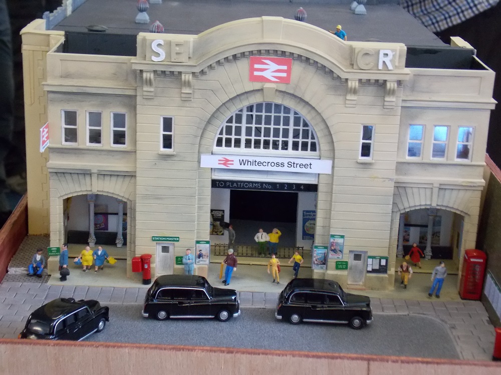
Whitecross Street
Set in the late 1960s/early 1970s (British Rail’s ‘Blue Period’) the layout represents a fictitious station and small parcels depot located near the real Moorgate Station. There was once an...
wealden.weebly.com

Prisons and the Metropolitan Railway
Whitecross Street Prison My attention was recently drawn to the plaque in the accompanying photograph. Cunningly designed in the style of official commemorative blue plaques, I noted the building s…
 machorne.wordpress.com
Last edited:
Crystal Span Bridge at Vauxhall by the Glass Age Development Committee (1963) - A design commissioned in 1963 for a replacement bridge at Vauxhall, inspired by the design of the Crystal Palace, to be called the Crystal Span.
The Crystal Span was to have been a seven-story building supported by two piers in the river, overhanging the river banks at either end. The structure itself would have been enclosed in an air conditioned glass shell.
The lowest floor would have contained two three-lane carriageways for vehicles, with a layer of shops and a skating rink in the centre of the upper floors. The southern end of the upper floors was to house a luxury hotel, whilst the northern end was to house the modern art collection of the nearby Tate Gallery, which at this time was suffering from a severe shortage of display space. The roof was to have housed a series of roof gardens, observation platforms and courtyards, surrounding a large open-air theater. The entire structure would have been 970 feet (300 m) long and 127 feet (39 m) wide.
1) https://www.ianvisits.co.uk/blog/2017/05/06/unbuilt-london-the-crystal-span-bridge/
2) http://blog.jeroenapers.nl/post/137804228691/de-crystal-span-een-voorstel-van-geoffrey

Oxford Street Flyover (1983) by Bryan Avery - The plan was for a three lane elevated road to run the length of Oxford Street, about 2 stories above the street level. Underneath would have been paved over and given to pedestrians along with small shops and bars, with escalators up to to the elevated street for bus stops and the like. In addition, one of the architect’s trademarks, would have been a glass canopy between the road and the shops, effectively turning the entire of Oxford Street into an indoor shopping mall. The elevated road would have dipped down to street level at Oxford Circus for the interchange, with pedestrians themselves being elevated over the road within a glass dome. - https://www.ianvisits.co.uk/blog/2016/01/16/unbuilt-london-the-oxford-street-flyover/
Bryan Avery later proposed a revamped version of the original 1983 proposal in 2016.

The following image is for a complete redevelopment of Oxford Street that unlike the later scheme above proposes the complete opposite with elevated walkways to separate pedestrians from street-level traffic, which can be found in the 1963 report Traffic in Towns that was also published by Penguin Books.

The Crystal Span was to have been a seven-story building supported by two piers in the river, overhanging the river banks at either end. The structure itself would have been enclosed in an air conditioned glass shell.
The lowest floor would have contained two three-lane carriageways for vehicles, with a layer of shops and a skating rink in the centre of the upper floors. The southern end of the upper floors was to house a luxury hotel, whilst the northern end was to house the modern art collection of the nearby Tate Gallery, which at this time was suffering from a severe shortage of display space. The roof was to have housed a series of roof gardens, observation platforms and courtyards, surrounding a large open-air theater. The entire structure would have been 970 feet (300 m) long and 127 feet (39 m) wide.
1) https://www.ianvisits.co.uk/blog/2017/05/06/unbuilt-london-the-crystal-span-bridge/
2) http://blog.jeroenapers.nl/post/137804228691/de-crystal-span-een-voorstel-van-geoffrey
Oxford Street Flyover (1983) by Bryan Avery - The plan was for a three lane elevated road to run the length of Oxford Street, about 2 stories above the street level. Underneath would have been paved over and given to pedestrians along with small shops and bars, with escalators up to to the elevated street for bus stops and the like. In addition, one of the architect’s trademarks, would have been a glass canopy between the road and the shops, effectively turning the entire of Oxford Street into an indoor shopping mall. The elevated road would have dipped down to street level at Oxford Circus for the interchange, with pedestrians themselves being elevated over the road within a glass dome. - https://www.ianvisits.co.uk/blog/2016/01/16/unbuilt-london-the-oxford-street-flyover/
Bryan Avery later proposed a revamped version of the original 1983 proposal in 2016.
The following image is for a complete redevelopment of Oxford Street that unlike the later scheme above proposes the complete opposite with elevated walkways to separate pedestrians from street-level traffic, which can be found in the 1963 report Traffic in Towns that was also published by Penguin Books.
Coin Street by Richard Rogers (1979?)

Watkin's Tower - Despite being a pre-1900s scheme, the image by one Mike Paterson below envisions a scenario where it is completed and still standing in the present day.

The Pinnacle (aka Helter Skelter) - Came the closest to becoming a reality however only the first seven floors of core made it above ground level before the project ran out of steam. What would have been the tallest, and most eye-catching building in the City was cancelled. The core has now been demolished and a less showy tower of similar height will rise in its place. - https://en.wikipedia.org/wiki/22_Bishopsgate

Fresh from designing two of the most shocking buildings in a generation, the Pompidou Centre and the Lloyds Building, the third part of Richard Rogers’ hat trick was to be a mixed-use scheme for Coin Street, on the South Bank of the Thames. Early versions from 1979 depicted a curving glass arcade, surrounded by high-rise housing and offices in his trademark “guts out” style. Had this gone ahead, it would have cemented Rogers’s early, extreme approach to architecture, and might have made a difference in some of the battles with conservative neo-traditionalists that dominated the 1980s.
Instead, a local campaign led to Coin Street being built as a low-rise housing cooperative, in what was widely considered a huge success for the provision of social housing to Londoners on lower incomes. Nevertheless, when Rogers returned to build in London more than a decade later, he had developed a mature, smoother, more commercially tasteful style, and you can’t help wonder if a whole generation of city buildings were far less bold as a result.
Watkin's Tower - Despite being a pre-1900s scheme, the image by one Mike Paterson below envisions a scenario where it is completed and still standing in the present day.
The Pinnacle (aka Helter Skelter) - Came the closest to becoming a reality however only the first seven floors of core made it above ground level before the project ran out of steam. What would have been the tallest, and most eye-catching building in the City was cancelled. The core has now been demolished and a less showy tower of similar height will rise in its place. - https://en.wikipedia.org/wiki/22_Bishopsgate
Devvy
Donor
And for some more rail based stuff (sorry):
Intercity 250
In 1989, a strategic review of the West Coast Main Line established 5 options for the WCML:
1) Do nothing and retain a 2:30 London-Manchester service
2) Accelerate the existing trains to 110mph and improve reliability, improving London-Manchester to 2:10
3) Add new trains capable of 140mph along with some speed restriction removals, improving London-Manchester to 2:00
4) Upgrade infrastructure to allow for 140-160mph services, and straighten some curves, improving London-Manchester to 1:50.
5) Build a new high speed line from London suburbs to Crewe, reducing London-Manchester to 1:35. (The line would start approx 30 miles from central London and end at Crewe).
OTL would see Intercity conclude that ample capacity existed on the line as it was, and so a new line couldn't be politically justified, but needed more than "do nothing" as much of the infrastructure was approaching life-expiration. Market studies carried out also showed "a strong resistance to premium fares".
As a result, the Intercity vision was to develop the existing routes for 160mph operation by using modern technology on existing tracks, and gradually straightening curves. A package of developments was to be put in hand to ensure 160mph oepration was deliverable by 2000. The Intercity 250 trainset would be originally designed to operate on the WCML, but would be equally suited to run on the straighter routes out of Kings Cross and Paddington.
The trainset:

Proposal 1:

Proposal 2:

First class mockup:

Intercity 250
In 1989, a strategic review of the West Coast Main Line established 5 options for the WCML:
1) Do nothing and retain a 2:30 London-Manchester service
2) Accelerate the existing trains to 110mph and improve reliability, improving London-Manchester to 2:10
3) Add new trains capable of 140mph along with some speed restriction removals, improving London-Manchester to 2:00
4) Upgrade infrastructure to allow for 140-160mph services, and straighten some curves, improving London-Manchester to 1:50.
5) Build a new high speed line from London suburbs to Crewe, reducing London-Manchester to 1:35. (The line would start approx 30 miles from central London and end at Crewe).
OTL would see Intercity conclude that ample capacity existed on the line as it was, and so a new line couldn't be politically justified, but needed more than "do nothing" as much of the infrastructure was approaching life-expiration. Market studies carried out also showed "a strong resistance to premium fares".
As a result, the Intercity vision was to develop the existing routes for 160mph operation by using modern technology on existing tracks, and gradually straightening curves. A package of developments was to be put in hand to ensure 160mph oepration was deliverable by 2000. The Intercity 250 trainset would be originally designed to operate on the WCML, but would be equally suited to run on the straighter routes out of Kings Cross and Paddington.
The trainset:
Proposal 1:
Proposal 2:
First class mockup:
en.wikipedia.org/wiki/Picc-Vic_tunnel
 www.liverpoolecho.co.uk
How we were all meant to use Liverpool's streets in the sky - and why we're not
Still many traces of system above our streets today
www.liverpoolecho.co.uk
Green Giant (1979) - Envisioned to be built next to Vauxhall Bridge on the site now occupied by the MI6 building, however the potential building site was on both sides of Vauxhall Bridge on the southbank of the Thames. The tower was planned for the Eastern side with the art gallery on the West – and a tunnel under the road linking them together. The site would have included 100 luxury flats, and 300,000 sq ft of office space, which is was said oil giant Esso was interested in renting. - https://www.ianvisits.co.uk/blog/2016/05/01/unbuilt-london-vauxhalls-green-giant/

London River Park (Cannon Street) - Basically a floating walkway between the Tower of London and and Blackfriars. - https://londonist.com/2011/09/new-images-of-london-river-park

Minerva (Aldgate) - An alternate proposal for the Minerva / St Botolph Building, which had planning permission to rise well above 200m near Aldgate until plans fizzled out in 2006 and followed by a squat less ambition building.

London River Park (Cannon Street) - Basically a floating walkway between the Tower of London and and Blackfriars. - https://londonist.com/2011/09/new-images-of-london-river-park
Minerva (Aldgate) - An alternate proposal for the Minerva / St Botolph Building, which had planning permission to rise well above 200m near Aldgate until plans fizzled out in 2006 and followed by a squat less ambition building.
Very fitting.[the] London Temple of Atheism....would have been hollow.
Selfridges Tower - One of a number of proposals for a Selfridges Tower beginning in 1918, the following below is a "Phase 3" 1925 model by Sir John Burnet as part of H. Gordon Selfridge's unrealised plans to include a huge tower or dome above the central section of the store.

Design for suggested multi-storey buildings around St Paul's Cathedral, City of London - This 1946 design by Joseph Emberton was one of many ideas for how to rebuild the City of London after the Blitz – with supertowers rising right around St Paul’s

East London Monorail - A recently rejected proposal for an East London Monorail, the only potentially salvageable thing about this scheme in ATL terms would be the prospect of parts of it being utilized by an ATL expanded Docklands Light Railway originating from Thamesmead to Collier Row (by Romford) via Belvedere or Romford via Belvedere by utilizing a repurposed Romford-Upminister line.- https://www.ianvisits.co.uk/blog/2019/05/07/could-east-london-be-about-to-get-a-monorail/

Design for suggested multi-storey buildings around St Paul's Cathedral, City of London - This 1946 design by Joseph Emberton was one of many ideas for how to rebuild the City of London after the Blitz – with supertowers rising right around St Paul’s
East London Monorail - A recently rejected proposal for an East London Monorail, the only potentially salvageable thing about this scheme in ATL terms would be the prospect of parts of it being utilized by an ATL expanded Docklands Light Railway originating from Thamesmead to Collier Row (by Romford) via Belvedere or Romford via Belvedere by utilizing a repurposed Romford-Upminister line.- https://www.ianvisits.co.uk/blog/2019/05/07/could-east-london-be-about-to-get-a-monorail/
Charing Cross Bridge (1889-1939+?)
The following image below is a 1927 proposal by Sir Owen Williams for a "Double-Decker" Charing Cross Bridge scheme, unlike many other proponents for a Charing Cross Bridge he seemed to be one of the few who thought a railway station on the north side of the Thames wasn't such a bad idea and suggested a dual-level bridge to replace the iron and steel lattice work that so offended architects at the time.
Unusually it seems the idea for a road bridge at Charing Cross was considered as late as Abercrombie's Greater London Plan for post-war London before finally disappearing into obscurity.
IMHO another potential candidate for having a mainline railway station demolished and replaced with a road bridge (had the railway been expanded underground as conceived in the 1946 London Railway Plan) would have to be Cannon Street.

Links:
- https://www.ianvisits.co.uk/blog/2014/07/27/how-charing-cross-railway-station-was-nearly-demolished/
- http://www.peterberthoud.co.uk/blog/16022016122651-plans-for-a-charing-cross-bridge-without-trains/
- https://en.wikipedia.org/wiki/Charing_Cross_railway_station#Proposed_closure_and_relocation
Venice on Thames next to Tower Bridge - https://www.ianvisits.co.uk/blog/2016/03/05/unbuilt-london-the-fake-venice-next-to-tower-bridge/

The following is a larger sized version of the 1963 proposal for the City of London Pedway network followed by what was built in OTL by 1992 (unfortunately could not find better online maps on the London Pedway).


Along with accommodating Cyclists in an expanded ATL London with a network elevated pedestrian walkways, there could also be other parts of the network that are underground such as a form of London Underline* (also here) as well as the likes of the Kingsway tramway subway being opened for Cycling, etc.
*- A few of the Tunnels in question would likely be used by the ATL Underground, however that does not preclude a heavily expanded ATL London Underline network using largely dedicated tunnels as opposed to disused tube tunnels and in turn where feasible linking up with the ATL London Pedway network as well as ATL London Cycle routes (e.g. Cycle Superhighways, Quietways, etc).
The likes of OTL 80s schemes such as Tillingham Hall were planned to be built near rail stops like West Horndon railway station. which in ATL would be within ATL Railway 5 and have been built early enough in the post-war period via a lenient Metropolitan Greenbelt with other new towns, etc being established to deal with the continual ATL London overspill.
By the late-19th century, Charing Cross was seen as being inconveniently placed. In 1889, the newly formed London County Council's John Burns proposed that the station and its approach should be demolished, with a road bridge put in place. The idea gained support within the council as it would allow the Strand to be widened and put a road crossing over the Thames that could bypass Whitehall. When the SECR went to Parliament asking for an act to strengthen the bridge in 1916, Burns suggested the station was in the wrong place and should be rebuilt on the south side of the Thames. The following year, an act was passed to reconstruct the bridge, with strict conditions about its appearance and a ban on enlarging the station building itself.
Ownership of Charing Cross passed to the Southern Railway (SR) in 1923 following the Big Four grouping. The line was electrified in 1926 to cater for suburban services. The lighter load of multiple-unit electric trains was found to put far less strain on the bridge, and so traffic was redesigned so that local services ran on the older section, with mainline services using the 1887 extension.
In 1926, the Royal Commission on Cross River Traffic proposed that Hungerford Bridge should be replaced by a double deck road / rail bridge, and a new Charing Cross station built to the east of the old one. The SR approved the idea as it would allow them to expand the station. Two years later, a proposal appeared again to build just a road bridge and relocate the station south of the Thames, as it was significantly cheaper. The Prime Minister Stanley Baldwin urged the SR to accept the proposal, as "a matter of national importance", but the bill failed in 1930 after the select committee did not accept building a new Charing Cross on the south bank. The proposal was formally rejected in 1936 by the London & Home Counties Traffic Advisory Committee, which revived the double-deck bridge option. The plans were all abandoned following the outbreak of World War II.
The following image below is a 1927 proposal by Sir Owen Williams for a "Double-Decker" Charing Cross Bridge scheme, unlike many other proponents for a Charing Cross Bridge he seemed to be one of the few who thought a railway station on the north side of the Thames wasn't such a bad idea and suggested a dual-level bridge to replace the iron and steel lattice work that so offended architects at the time.
Unusually it seems the idea for a road bridge at Charing Cross was considered as late as Abercrombie's Greater London Plan for post-war London before finally disappearing into obscurity.
IMHO another potential candidate for having a mainline railway station demolished and replaced with a road bridge (had the railway been expanded underground as conceived in the 1946 London Railway Plan) would have to be Cannon Street.
Links:
- https://www.ianvisits.co.uk/blog/2014/07/27/how-charing-cross-railway-station-was-nearly-demolished/
- http://www.peterberthoud.co.uk/blog/16022016122651-plans-for-a-charing-cross-bridge-without-trains/
- https://en.wikipedia.org/wiki/Charing_Cross_railway_station#Proposed_closure_and_relocation
Venice on Thames next to Tower Bridge - https://www.ianvisits.co.uk/blog/2016/03/05/unbuilt-london-the-fake-venice-next-to-tower-bridge/
The following is a larger sized version of the 1963 proposal for the City of London Pedway network followed by what was built in OTL by 1992 (unfortunately could not find better online maps on the London Pedway).
Along with accommodating Cyclists in an expanded ATL London with a network elevated pedestrian walkways, there could also be other parts of the network that are underground such as a form of London Underline* (also here) as well as the likes of the Kingsway tramway subway being opened for Cycling, etc.
*- A few of the Tunnels in question would likely be used by the ATL Underground, however that does not preclude a heavily expanded ATL London Underline network using largely dedicated tunnels as opposed to disused tube tunnels and in turn where feasible linking up with the ATL London Pedway network as well as ATL London Cycle routes (e.g. Cycle Superhighways, Quietways, etc).
The likes of OTL 80s schemes such as Tillingham Hall were planned to be built near rail stops like West Horndon railway station. which in ATL would be within ATL Railway 5 and have been built early enough in the post-war period via a lenient Metropolitan Greenbelt with other new towns, etc being established to deal with the continual ATL London overspill.
A new update to the London Ringways that explores the Northern radials, one of which includes a non-official proposal to improve the existing A12 (akin to the modern A3 Kingston Bypass had it gone ahead) with a double-deck Y-shaped flyover at Gants Hill that also links up with a nearby branch of the North Circular Road. - https://www.roads.org.uk/ringways/northern

The following map is shows a 1855 Regents Canal and Railway Company plan from roughly OTL Moorgate and Westferry (aka Limehouse) to Paddington, the link meanwhile is to the later 1892 "District Railway Map of London" showing the Regent's Canal, City & Docks Railway (RCCDR) from roughly Barbican and Westferry to Paddington (around Royal Oak). - The District Railway Map of London link
What is fascinating about the Regents Canal Rail schemes (particularly the later further refined version) is how it appears to open up the possibility for an expanded ATL Docklands Light Railway (see here, here, here - specifically the DLR part and here*) to potentially link up with some form of North and West Light Railway at Finchley Road towards Finchley Central.
*- A further extension of the route of part of the Hertford Union Canal near Hackney Wick also opens up the possibility of an additional branch towards Beckton / Barking Riverside and Thamesmead via the present day Greenway footpath. - https://en.wikipedia.org/wiki/Greenway_footpath,_London
A case could also be made for a DLR branch linking the proposed route to Victoria with some version of the Regents Canal rail-based route to Paddington, yet can also see other possibilities for other lines as well.

A proposal for a tunnel to replace Tower Bridge, with the tunnel possibly running from Jamaica Road in the south to Thomas More Street on the north side had it been built. - https://www.ianvisits.co.uk/blog/2020/04/08/unbuilt-london-replacing-tower-bridge-with-a-tunnel/
IMHO it would have been interesting seeing an ATL tunnel existing alongside the OTL Tower Bridge (that was upgraded and the bridge road sections strengthened albeit still with a weight and speed limit up to the present), since the tunnel was to be located a quite a bit away from the bridge or a similarly updated version of the Crystal Tower Bridge proposal by W.F.C Holden (1943).
Willingale Airport - via RAF Chipping Ongar) - A little known shelved proposal for London's 3rd Airport located between Chipping Ongar and Chelmsford, there were also plans to upgrade the Central Line's Epping to Ongar branch and extend it to the Airport had it been built. There was previously a PDF of a 1979 flight global article that no longer exists, leaving only the following PDF. - http://www.willingale.me/tng2/press/New_airportSix_blight_spots_The_Economist_M.pdf
Central London Rail Study 1989 (PDF) - Highlights Include:
And for something outside of London.
Crossrail Glasgow (formerly known as Glasgow Crossrail) - A proposed railway development in Central Scotland to connect the stations Glasgow Central and Queen Street. - https://en.wikipedia.org/wiki/Crossrail_Glasgow
The following map is shows a 1855 Regents Canal and Railway Company plan from roughly OTL Moorgate and Westferry (aka Limehouse) to Paddington, the link meanwhile is to the later 1892 "District Railway Map of London" showing the Regent's Canal, City & Docks Railway (RCCDR) from roughly Barbican and Westferry to Paddington (around Royal Oak). - The District Railway Map of London link
What is fascinating about the Regents Canal Rail schemes (particularly the later further refined version) is how it appears to open up the possibility for an expanded ATL Docklands Light Railway (see here, here, here - specifically the DLR part and here*) to potentially link up with some form of North and West Light Railway at Finchley Road towards Finchley Central.
*- A further extension of the route of part of the Hertford Union Canal near Hackney Wick also opens up the possibility of an additional branch towards Beckton / Barking Riverside and Thamesmead via the present day Greenway footpath. - https://en.wikipedia.org/wiki/Greenway_footpath,_London
A case could also be made for a DLR branch linking the proposed route to Victoria with some version of the Regents Canal rail-based route to Paddington, yet can also see other possibilities for other lines as well.
A proposal for a tunnel to replace Tower Bridge, with the tunnel possibly running from Jamaica Road in the south to Thomas More Street on the north side had it been built. - https://www.ianvisits.co.uk/blog/2020/04/08/unbuilt-london-replacing-tower-bridge-with-a-tunnel/
IMHO it would have been interesting seeing an ATL tunnel existing alongside the OTL Tower Bridge (that was upgraded and the bridge road sections strengthened albeit still with a weight and speed limit up to the present), since the tunnel was to be located a quite a bit away from the bridge or a similarly updated version of the Crystal Tower Bridge proposal by W.F.C Holden (1943).
Willingale Airport - via RAF Chipping Ongar) - A little known shelved proposal for London's 3rd Airport located between Chipping Ongar and Chelmsford, there were also plans to upgrade the Central Line's Epping to Ongar branch and extend it to the Airport had it been built. There was previously a PDF of a 1979 flight global article that no longer exists, leaving only the following PDF. - http://www.willingale.me/tng2/press/New_airportSix_blight_spots_The_Economist_M.pdf
Central London Rail Study 1989 (PDF) - Highlights Include:
- North-South Crossrail
- East-West Crossrail
- City Crossrail
- Chelsea-Hackney Tube Line
- Jubilee Line proposed extension to Ilford from Charing Cross via Liverpool Street and Whitechapel
- Central Line to Richmond from Shepherds Bush via Turnham Green (possibly via Goldhawk Road) by a takeover of the District Line's Richmond Branch, which is essentially a recent version of an earlier Central extension to Richmond.
- Bakerloo Line takeover of the Central Line's Ealing Broadway Branch from Queens Park via North Acton (with a possible stop at Old Oak Common) as well as a Bakerloo Line southern extension from Elephant & Castle to Lewisham, Croydon and Crystal Palace.
- What appears to be an overlapping Victoria line scheme between Victoria and King's Cross to presumably increase capacity on the line in the core section.
- Thameslink Metro
- Docklands Second Line from Waterloo to Westcombe Park, seems to be the OTL Waterloo Greenwich Railway part of which was utilized by the OTL Jubilee Line rather than an actual Docklands Light Railway route.
And for something outside of London.
Crossrail Glasgow (formerly known as Glasgow Crossrail) - A proposed railway development in Central Scotland to connect the stations Glasgow Central and Queen Street. - https://en.wikipedia.org/wiki/Crossrail_Glasgow
Share: