There's this one from the day of the American Revolution.anyone have a map of the world right before the American revolution
You are using an out of date browser. It may not display this or other websites correctly.
You should upgrade or use an alternative browser.
You should upgrade or use an alternative browser.
Q-Bam Historical Map Thread
- Thread starter The Alternative
- Start date
-
- Tags
- historical maps q-bam
anyone have a map of the world right before the American revolution
But bear in mind that this seems to be the most up-to-date one: https://www.alternatehistory.com/fo...ical-map-thread.404984/page-135#post-24061381There's this one from the day of the American Revolution.

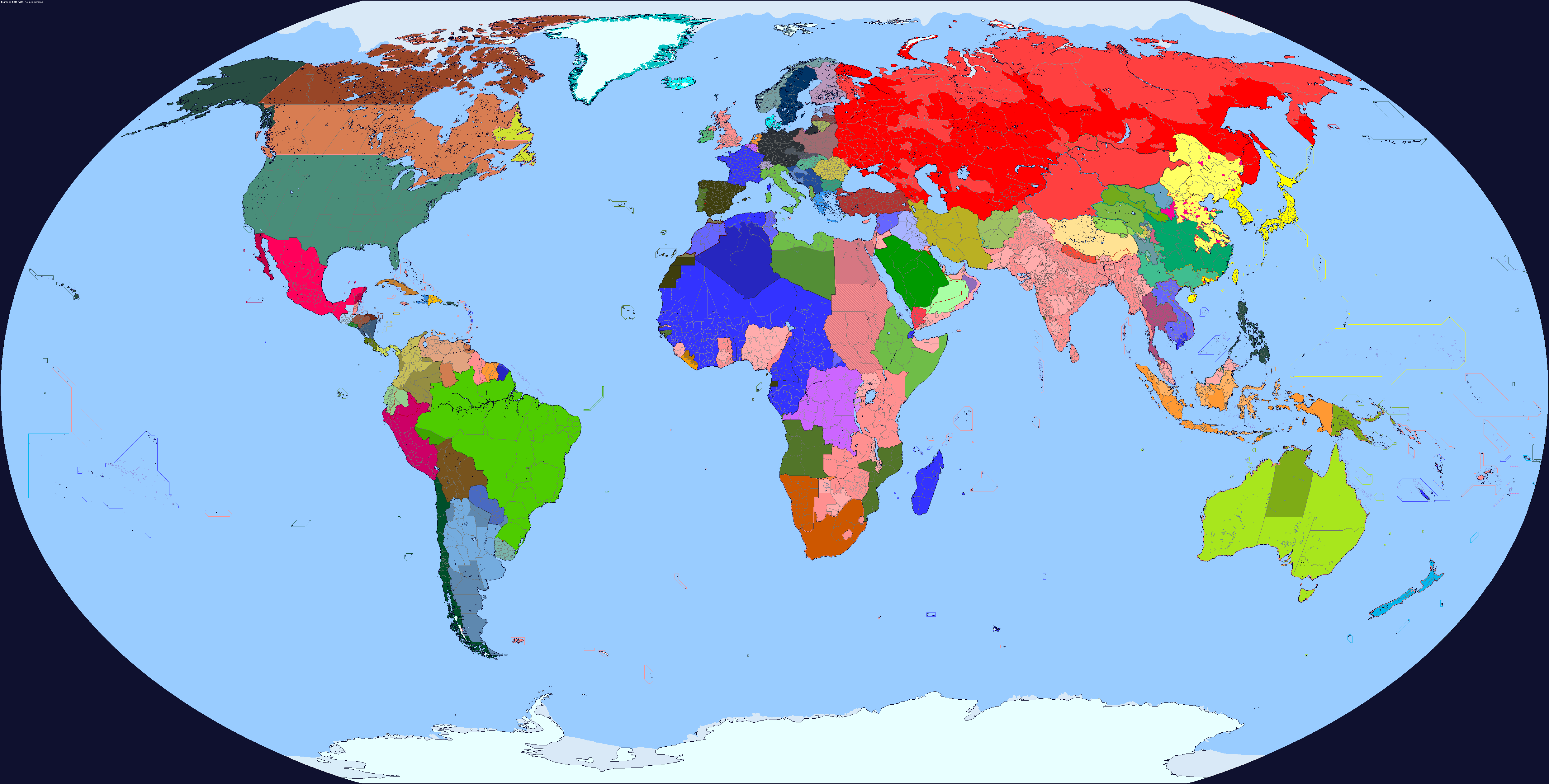
September 1, 1939
Trying out some new border colors, and trying to represent still-official nations like the Dominions of GB and vassal/client/autonomous states that still have political relevance
Last edited:
September 1, 1939
Trying out some new border colors, and trying to represent still-official nations like the Dominions of GB and vassal/client/autonomous states that still have political relevance
Amazing. Somehow the same base map with the combined Northumberland Durham county is still being used after years of complaints. I simply don't understand why this is still an issue after YEARS.
i've legit spent maybe half a year back in 2020 going insane trying to find explanations for why Northumberland and Durham were united for such long periods of time but were separate bot today and in the middle ages before i was informed that it's just a poor basemapAmazing. Somehow the same base map with the combined Northumberland Durham county is still being used after years of complaints. I simply don't understand why this is still an issue after YEARS.
FixedAmazing. Somehow the same base map with the combined Northumberland Durham county is still being used after years of complaints. I simply don't understand why this is still an issue after YEARS.
Right - when you go and search for previous copies of British subdivisions, 2/3rds or more of them have that mistake replicated. Unless you actually remember to go and fix it or you get lucky finding a patched basemap, then your the will probably just be replicated over to the new map.i've legit spent maybe half a year back in 2020 going insane trying to find explanations for why Northumberland and Durham were united for such long periods of time but were separate bot today and in the middle ages before i was informed that it's just a poor basemap
i really hate to be That Person but the USSR is so garishly red it hurts to look at
September 1, 1939
Trying out some new border colors, and trying to represent still-official nations like the Dominions of GB and vassal/client/autonomous states that still have political relevance
It looks like it always does what's the big deal? Do you hate red as a color or something? U.ui really hate to be That Person but the USSR is so garishly red it hurts to look at
I would like to suggest one small correction about the Nagorno-Karabakh Autonomous Oblast and the Red Kurdistan region according to this map:
September 1, 1939
Trying out some new border colors, and trying to represent still-official nations like the Dominions of GB and vassal/client/autonomous states that still have political relevance
It looks like it always does what's the big deal? Do you hate red as a color or something?i really hate to be That Person but the USSR is so garishly red it hurts to look at
Some people have different sets of eyes than you do with varying qualities and weaknesses. Most people might not be bothered by the brightness of the red (I'm not) but a few will be. Heck, there are things which most people can see which I can't. It's why I wear glasses.It looks like it always does what's the big deal? Do you hate red as a color or something?
I'm genuinely asking for his reasons because I want to know, I wasn't criticizing his opinion.Some people have different sets of eyes than you do with varying qualities and weaknesses. Most people might not be bothered by the brightness of the red (I'm not) but a few will be. Heck, there are things which most people can see which I can't. It's why I wear glasses.
no, i don't hate the colour red, it's moreso that bright neon colours are painful to look at and the USSR being as large as it is doesn't exactly helpIt looks like it always does what's the big deal? Do you hate red as a color or something?
also, *they. but given the exceptionally pronounced gender ratio when it comes to the AH community, i can understand why you defaulted to assuming i was a guyI'm genuinely asking for his reasons because I want to know, I wasn't criticizing his opinion.
I wasn't aware of your chosen pronouns fyi, son nothing meant by that you understood what my brain did because this is the Internet (ancient joke is ancient) but subjectivity must really matter here because I wouldn't characterize the Soviet red color as 'neon' in intensity. Though I have never looked at any of my own or others maps on a particularly large display (like any larger than a laptop display would be) so maybe that's a factor too (also now I'm primarily stuck looking at maps via my phone screen which exacerbates that possibility >_<)no, i don't hate the colour red, it's moreso that bright neon colours are painful to look at and the USSR being as large as it is doesn't exactly help
also, *they. but given the exceptionally pronounced gender ratio when it comes to the AH community, i can understand why you defaulted to assuming i was a guy
screen size may play a part in it, i will agree. i only ever use this site on desktop so even in preview there's a lot of eyestrain looking at how bright the USSR is. i think part of the issue is also the fact the colours of the countries (and water) surrounding it aren't quite as bright, thus making it worseI wasn't aware of your chosen pronouns fyi, son nothing meant by that you understood what my brain did because this is the Internet (ancient joke is ancient) but subjectivity must really matter here because I wouldn't characterize the Soviet red color as 'neon' in intensity. Though I have never looked at any of my own or others maps on a particularly large display (like any larger than a laptop display would be) so maybe that's a factor too (also now I'm primarily stuck looking at maps via my phone screen which exacerbates that possibility >_<)
Share: